Mission Summary
20050716H1 Aircraft 42RF
IFEX Genesis Flight 2005
| Rob Rogers | Lead Scientist |
| Paul Leighton | Workstation |
| Shirley Murillo | Dropsonde |
| Pilots | Phil Kennedy Barry Choy |
| Flight Engineers | Steve Wade |
| Navigators | Tim Gallagher |
| Flight Director | Paul Flaherty |
| Data Engineers | Sean McMillan John Hill Mark Rogers |
Mission Plan :
Daytime follow-on mission to investigate suspect area in the eastern Pacific. System shows some possible signs of a cyclonic circulation in the mid- and low-levels, as identified by drops on previous nightÕs mission. Fly a square-spiral pattern on the suspected circulation center at 14,000 ft altitude. There was not the flare-up of convection overnight that was hoped for, but the drops did reveal at least the possibility of a circulation. The flight today should reveal that.
Mission Summary :
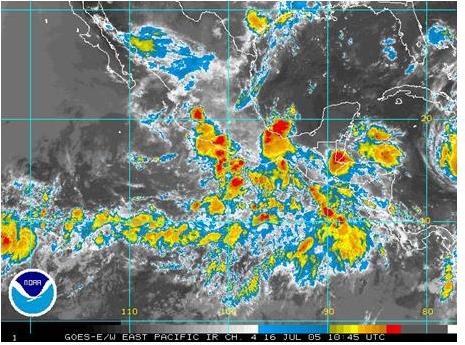 There was not as much convection as had been hoped for in the target area during the previous night. Infrared imagery in the early morning (Fig. 1) showed widespread convection over much of the Eastern Pacific basin, but none of it was particularly well-organized. Over the target zone (about 10 N 90 W), there was some small areas of deep convection and stratiform precipitation off to the southeast. From the pattern of the clouds in the image, it appears that the vertical shear has relaxed somewhat over much
 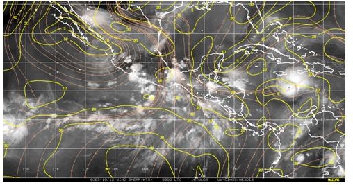 of the basin. This is confirmed by the CIMSS shear analysis (Fig. 2), which indicates that shear values dropped everywhere off the coasts of southern Mexico and western Central America. Over the target area shear values are around 15 kt.
The previous days' flights indicated that there was a circulation center or shear axis at flight level (around 14,000 ft.). The pattern from the previous N43RF night flight suggests that they clipped the southern edge of the wind shift. From the dropsonde data from the N43RF night flight, the center was estimated to be located at 9.25 N 88 W. Assuming that 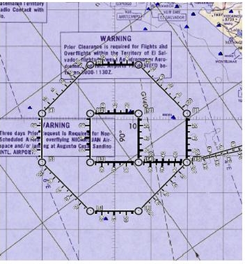 this feature is coherent and can be tracked in time, and assuming a generally westward movement of about 4 degrees/day, the feature was estimated to be located at about 9.5 N 90 W, which is where the center of today's pattern is located. The pattern to be flown is the square-spiral pattern (Fig. 3), which consists of flying two concentric circuits around a target, which in this case was the estimated location of the feature. Takeoff time was set for 1730 UTC. A total of 16 GPS drops and 8 AXBT's were planned (Fig. 4).
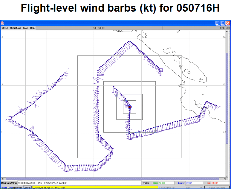
As the IP was approached southeast of the target, flight-level winds (Fig. 5) were generally southeasterly and south-southeasterly.
Once the pattern began, flight-level winds remained south-southeasterly and turned southerly after the first turn. There were some clouds in the environment, but they were mostly stratiform anvil debris. Near the turn toward the west, the winds at flight level rapidly changed direction to easterly and then northeasterly. The aircraft entered moderate to heavy stratiform rain as it tracked westward, with some embedded echoes of moderate convection. This was confirmed by infrared imagery just prior to takeoff (Fig. 6). The strongest turbulence of the deployment (8 m/s updraft, 3 m/s downdraft couplet) was encountered here. Flight-level winds were from the east, and it was in this part of the pattern that surface winds were strong easterlies. One dropsonde in this area measured easterly surface winds of 20 kts, and the SFMR measured winds as high as 25 kt, but that was likely localized to a convective downdraft. Thermodynamic profiles were nearly saturated moist-adiabatic in much of this region.
On the SW portion of the outer ring, very weak winds at flight-level were encountered. Some weak northwesterly winds were also measured here. As the aircraft moved further southwest, the flight-level winds shifted to southwesterlies. It was at this point that it became clear that the pattern had missed the center of this wind shift. It appeared that the center or axis of this feature was further north and west than what had been predicted. As a result a modification to the pattern was made to extend the southwest-oriented leg instead of turning south. This would extend the westward extent of the pattern, hopefully sampling more northwesterly winds. Despite this change in pattern, though, flight-level winds remained westerly and southwesterly, indicating that either the center of the circulation or the axis of the wind shift remained to the north of the aircraft.
The southern portion of the pattern remained in south-southwesterly and southerly winds at flight-level and at the surface. There were very few clouds in this area either, except for occasional anvil debris 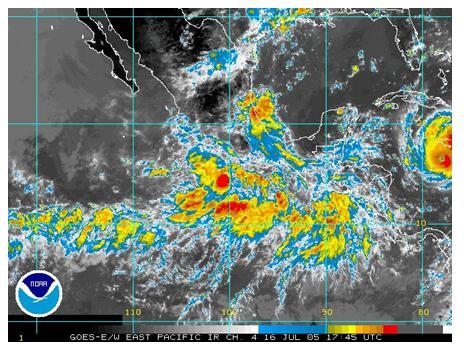 being blown from the north to the south. Dropsondes released in this area showed deep southerlies. The relative humidity on these drops was also rather low. Sea-surface temperatures were about 27.5 degrees on the south side of the pattern, lower than the 28-28.5 degree temperatures seen in the northern part of the pattern. The advection of drier air over cooler water may have played a role in preventing deep convection in forming during the previous night.
Upon completion of the outer ring, the inner ring was begun. As that portion was begun, an idea arose to modify this portion of the track by abandoning the inner ring and instead track toward the northeast, outside of the outer ring, and fly down off the coast of Nicaragua back to base. The reason for this modification was to see if the source of the easterlies seen earlier in the pattern was generated from the system itself or if it was an easterly jet caused by flow through the mountain passes of Nicaragua. Two drops released along this leg showed weak easterly flow. This supports the contention that the strong easterlies seen earlier in the pattern were generated locally by the system and not topographically-forced. The aircraft returned to San Jose, landing at 0046 UTC.
It is not clear what the system was that was flown over the past 36 h. Satellite imagery from a day and half earlier showed widespread cold cloud tops indicative of the presence of deep convection. This convection may have simply been ITCZ convection, or it may have been associated with a discrete system with origins in the ITCZ. The convection that prompted the identification of this feature as a target certainly appeared to be ITCZ convection, but flight level data seemed to suggest that there was in fact a closed circulation, at least at flight level. Unfortunately, neither of the final two flights flew far enough to the north and west to say definitively if there was in fact a closed circulation. There did appear to be a coherent center or shear axis that could be tracked from flight to flight. The N42RF flight on Friday put the flight roughly at 7.5 N 86 W. Estimates of the center from the N43RF night flight placed it at about 9.75 N 89 W. Extrapolating those positions for the center point during the second N42RF flight would put it at about 12 N 92 W. This is well north and west of the center of the pattern, which was made at 9.5 N 90 W. In retrospect, the square-spiral pattern probably was not the best pattern to fly in this case, since that presumes a knowledge of the center of the circulation. The diamond pattern would have been better here, because it would have allowed for more flexibility in surveying the flight-level winds to find any possible circulation center. Nonetheless, dropsonde and Doppler wind data should provide a sufficient monitoring of the system to be able to determine its structure and evolution, including whether or not it was simply an ITCZ-related shear axis or a midlevel mesovortex perhaps generated or modified by the convection on the previous morning which formed along the ITCZ. Radar-derived winds from this day's flight should help in identifying the structure of this system, since the area with the most widespread rainfall was co-located with the circulation center/shear axis and extended to the north and west of it.
Problems :
There were no major problems on this flight. All instruments performed well.
Data :
| Start | End |
| 18:52:52 Z | 00:25:11 Z |
Taken from this AOML page
Wind NOAA-42


